A Note from Fatty: I’ve been quietly and secretly working on a big project recently. Monday I’ll announce it.
Another Note from Fatty: Today’s story, by Chris C, strikes kinda close to home, since I’ve been stuck in essentially the same place. It’s a great story of suffering. Enjoy!
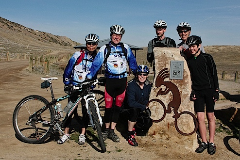
Mid-March might be too early to ride Kokopelli’s Trail, but that’s exactly what my friends John and Kathleen and I set out to do. We are not novice riders: we’ve done distance, we’ve done mountains, and we’re all LT100 vets. Supporting us was our friend Doug (and his dad and son). He’s quick-thinking, even-tempered, and is himself an experienced enduro rider.

The whole group, left to right: Kathleen Porter, John Adamson, Doug Keiser, Chris Congdon, John Keiser, Brian Keiser
The third day was to be our toughest. 42 miles is not a long distance, but the terrain would be challenging. (Cowskin to Rock Castle) We’d start with a climb up a mesa, then down into and up out of two canyons … and then after lunch, a steady 18 mile climb to a point called Bull Draw, on top of a mesa at 8500 ft. At Bull Draw, our dirt road was to become paved for a nice six mile descent to camp.
The day began beautifully. The scenery was sensational as we dropped into slot canyons, riding rock trails and ledges. We made our lunch stop in the Fisher Valley. On this day, there was only one possible spot to bail out of the Kokopelli Trail, and this was it. It was 2:15 in the afternoon. It didn’t dawn on us that we had only covered half of our distance, but had already used more than half of our daylight. We had 18 miles of climbing ahead, but 18 miles is about the distance of one of my typical lunch-hour gravel road rides so why worry?
The road out of Fisher Valley was soft so it was hard to maintain momentum. Kathleen was feeling sluggish. Kat’s a strong rider, we all have our off days – unfortunately, this was one of hers. We were making only three miles an hour.
After setting up our campsite, Doug drove up to Bull Draw at the top of the mesa, and looked out in the direction from which we would come. As far as he could see, our route was covered in snow. We were heading into a mountain pass that hadn’t been traversed on anything other than a snowmobile since sometime last autumn. Doug drove the 30 or 40 miles back down the mesa, and then up the Fisher Valley to our bail-out spot, as he considered the snowfield impassible. Throughout the afternoon he’d occasionally try his cell phone, but there was no service in the valley.
On the trail, we continued climbing. I would ride a mile and then we’d stop to regroup. Kathleen was struggling. Sometimes John would ride with me and sometimes with Kat. Mostly he hung between us – keeping Kat in sight, but not piling on any more pressure. It was getting cooler as we climbed. We each had a light jacket in our packs, but that was it for extra clothing.
With about six miles to go in our climb we hit the first snowbank. It was small and we missed its monumental significance … that we were approaching the snowline, we still had six miles of climbing, and daylight was getting away from us.
The road became a sticky gumbo that collected on our tires and drivetrains and then our wheels wouldn’t go around anymore. We walked, slipping and sliding, pushing our bikes which had to weigh about 40lb with all the collected mud. After about an hour, we held a little council. Should we turn around? Ahead was 4 more miles of climbing – probably walking – and by this point turning around and going downhill in the mud also meant walking. We realized too late that we were in too deep.
We talked of splitting up, with me going ahead to tell Doug what was happening, but decided to stay together. I had a survival blanket in my pack, and if we had to spend the night on out on this mesa, we’d be warmer together. Also, we’d been seeing big kitty tracks. I didn’t want to be alone in the wilderness after dark. We’d occasionally try a cell phone call to Doug, but here in canyon country, we couldn’t connect. Kat fired off a text, thinking that Doug would receive it whenever he got back into coverage. John & I didn’t know what the text said. We pushed on. At nearly the last moment with enough daylight to read the map, we fixed our position with about 2.5 more miles of climbing to Bull Draw. We also had reached the snowfield.
During this time, Doug had made the round trip again from valley to mesa to valley to see if there was any sign of us. He was more than concerned. He didn’t consider the snowfield to be passable and yet we were not down in the valley, either. He concluded that we were in trouble, and that he was not going to be able to help us on his own.
We were struggling in the snowfield. I don’t want to over-dramatize our situation: we knew where we were, we had food, water and my survival blanket for shelter. But, you don’t have to read too many issues of Backpacker magazine to find a similar story with a grim ending. Our cause was not lost, but we had used up our allotment of bad decisions. We had to be hyper-alert for hypothermia and that precise moment when NOW is the time to stop and shelter-up for the night.
We had two miles to walk, in the dark, in the snow, in our spandex clothes and plastic shoes. Our mud-caked bikes were now accumulating ice as well. Every few steps they’d break through the crusty surface and sink to the hubs, and we’d have to heft them up again. It was totally exhausting.
Carrying the bike was too much for Kat, and she simply abandoned hers. She was stumbling a little and her teeth were chattering and I was scared for her, but it didn’t seem time to stop just yet. I walked ahead a little bit, trying to focus on the distant point that I hoped was Bull Draw. John kept encouraging both of us, and tried breaking a track for Kat to walk in. We walked single file, stopping often to rest, and in time, we tried Kat’s phone again.
Doug had decided to drive out of Fisher Valley until he had cell service, and then call for help. He had gone a few miles when his phone chimed. He stopped, read the text from Kat. “HELP” As he moved to dial 911 the phone rang in his hand. It was us.
We were able to tell Doug that we were in the snowfield with maybe a mile and a half to Bull Draw and he was able to tell us that the paved road down the other side was open and he would meet us there. At that point John and I also abandoned our bikes and we put our efforts into moving forward together.
John took the point and we walked like blind people, single file with our hands on the shoulders of the one in front. We could hear the wind roaring over our head, coming up from the other side of the mesa. We’d do about thirty steps, rest, thirty steps, rest. Our feet were freezing and the icy crust bloodied our shins.
And then … eventually … the snow wasn’t quite as deep. Snow became slush became mud and finally we were on blacktop. The icy wind made us have to shout at each other, but we were on pavement, walking downhill, holding hands: obviously the first cyclists to crest Bull Draw from Fisher Valley in the 2011 season. Ten minutes later we were in the truck.
Doug calls our cell connection a God thing, and I’m with him on that — what else could it be on a day that had offered no other communication? It would take a while for us to really warm up, and as tired as I was, I didn’t sleep very well that night. You can imagine that this has left us with a lot to talk about: bad decisions, fear, exhaustion. But we do these things for the experience — to have a story to tell.
And, I think it was at breakfast the next morning when John kind of smiled and said, “It was the best!”
 About the Author: Chris Congdon is Media Coordinator at First United Methodist in Cedar Falls, Iowa. He loves road TTs and MTB XC racing. He says he’s not good at either, but has a ton of fun.